

A lot of social media and mainstream media commentary went on to debate and on few occasions accuse state governments about the decisions they took.
Because of all this information flying around you might be wondering why sometimes the extraordinary emphasis is put on some council areas when lockdowns and restrictions are imposed.
To ease that sense of anxiety here is some data to help you understand.
New South Wales:
Locally acquired COVID-19 cases and tests in the last four weeks – up to 8pm 22 July 2021

NSW saw 136 locally acquired cases reported to 8 pm last night, 62 are from South Western Sydney Local Health District (LHD), 29 are from Western Sydney LHD, 28 are from Sydney LHD, 14 are from South Eastern Sydney LHD.
COVID-19 cases and tests by local government area-
| Local Government Area | Cases* | Cases with unknown source | Total tests | Test rate (per 1000) |
|---|---|---|---|---|
| Albury | 0 | 0 | 5,037 | 93 |
| Armidale Regional | 0 | 0 | 2,267 | 74 |
| Ballina | 0 | 0 | 2,768 | 62 |
| Balranald | 0 | 0 | 202 | 86 |
| Bathurst Regional | 0 | 0 | 5,001 | 115 |
| Bayside | 49 | 5 | 42,923 | 241 |
| Bega Valley | 0 | 0 | 2,277 | 66 |
| Bellingen | 0 | 0 | 1,077 | 83 |
| Berrigan | 0 | 0 | 291 | 33 |
| Blacktown | 54 | 22 | 69,001 | 184 |
| Bland | 0 | 0 | 312 | 52 |
| Blayney | 0 | 0 | 1,311 | 178 |
| Blue Mountains | 2 | 0 | 16,835 | 213 |
| Bogan | 0 | 0 | 122 | 47 |
| Bourke | 0 | 0 | 343 | 132 |
| Brewarrina | 0 | 0 | 69 | 43 |
| Broken Hill | 0 | 0 | 1,185 | 68 |
| Burwood | 9 | 3 | 6,953 | 171 |
| Byron | 0 | 0 | 2,744 | 78 |
| Cabonne | 1 | 0 | 1,118 | 82 |
| Camden | 3 | 2 | 30,790 | 304 |
| Campbelltown | 14 | 3 | 36,965 | 216 |
| Canada Bay | 6 | 0 | 20,444 | 213 |
| Canterbury-Bankstown | 224 | 61 | 99,956 | 264 |
| Carrathool | 0 | 0 | 141 | 50 |
| Central Coast | 3 | 0 | 50,780 | 148 |
| Central Darling | 0 | 0 | 97 | 53 |
| Cessnock | 0 | 0 | 3,639 | 61 |
| Clarence Valley | 0 | 0 | 2,641 | 51 |
| Cobar | 0 | 0 | 218 | 47 |
| Coffs Harbour | 0 | 0 | 7,285 | 94 |
| Coolamon | 0 | 0 | 303 | 70 |
| Coonamble | 0 | 0 | 261 | 66 |
| Cootamundra-Gundagai Regional | 0 | 0 | 1,161 | 103 |
| Cowra | 0 | 0 | 836 | 66 |
| Cumberland | 111 | 32 | 57,152 | 237 |
| Dubbo Regional | 0 | 0 | 4,422 | 82 |
| Dungog | 0 | 0 | 602 | 64 |
| Edward River | 0 | 0 | 463 | 51 |
| Eurobodalla | 0 | 0 | 2,780 | 72 |
| Fairfield | 677 | 160 | 112,282 | 530 |
| Federation | 0 | 0 | 799 | 64 |
| Forbes | 0 | 0 | 496 | 50 |
| Georges River | 64 | 14 | 39,230 | 246 |
| Gilgandra | 0 | 0 | 215 | 51 |
| Glen Innes Severn | 0 | 0 | 366 | 41 |
| Goulburn Mulwaree | 0 | 0 | 3,439 | 110 |
| Greater Hume Shire | 0 | 0 | 1,268 | 118 |
| Griffith | 0 | 0 | 2,206 | 82 |
| Gunnedah | 0 | 0 | 747 | 59 |
| Gwydir | 0 | 0 | 167 | 31 |
| Hawkesbury | 6 | 0 | 13,404 | 199 |
| Hay | 0 | 0 | 182 | 62 |
| Hilltops | 0 | 0 | 1,276 | 68 |
| Hornsby | 4 | 0 | 22,103 | 145 |
| Hunters Hill | 1 | 0 | 5,972 | 399 |
| Inner West | 10 | 3 | 45,806 | 228 |
| Inverell | 0 | 0 | 851 | 50 |
| Junee | 0 | 0 | 313 | 47 |
| Kempsey | 0 | 0 | 2,194 | 74 |
| Kiama | 0 | 0 | 3,398 | 145 |
| Ku-ring-gai | 0 | 0 | 27,426 | 216 |
| Kyogle | 0 | 0 | 369 | 42 |
| Lachlan | 0 | 0 | 277 | 46 |
| Lake Macquarie | 0 | 0 | 24,315 | 118 |
| Lane Cove | 1 | 1 | 14,559 | 363 |
| Leeton | 0 | 0 | 701 | 61 |
| Lismore | 0 | 0 | 2,895 | 66 |
| Lithgow | 0 | 0 | 1,574 | 73 |
| Liverpool | 126 | 31 | 66,543 | 292 |
| Liverpool Plains | 0 | 0 | 408 | 52 |
| Lockhart | 0 | 0 | 225 | 68 |
| Maitland | 0 | 0 | 11,277 | 132 |
| Mid-Coast | 0 | 0 | 5,530 | 59 |
| Mid-Western Regional | 0 | 0 | 2,205 | 87 |
| Moree Plains | 0 | 0 | 539 | 41 |
| Mosman | 0 | 0 | 6,062 | 196 |
| Murray River | 0 | 0 | 232 | 19 |
| Murrumbidgee | 0 | 0 | 224 | 57 |
| Muswellbrook | 0 | 0 | 1,137 | 69 |
| Nambucca | 0 | 0 | 1,412 | 71 |
| Narrabri | 0 | 0 | 528 | 40 |
| Narrandera | 0 | 0 | 238 | 40 |
| Narromine | 0 | 0 | 402 | 62 |
| Newcastle | 0 | 0 | 20,054 | 121 |
| North Sydney | 3 | 0 | 12,071 | 161 |
| Northern Beaches | 9 | 0 | 64,121 | 234 |
| Oberon | 0 | 0 | 396 | 73 |
| Orange | 0 | 0 | 5,932 | 140 |
| Parkes | 0 | 0 | 1,267 | 85 |
| Parramatta | 41 | 15 | 45,648 | 177 |
| Penrith | 13 | 2 | 39,768 | 187 |
| Port Macquarie-Hastings | 0 | 0 | 6,822 | 81 |
| Port Stephens | 0 | 0 | 6,007 | 82 |
| Queanbeyan-Palerang Regional | 0 | 0 | 3,645 | 60 |
| Randwick | 54 | 4 | 66,972 | 430 |
| Richmond Valley | 0 | 0 | 1,522 | 65 |
| Ryde | 1 | 0 | 28,592 | 218 |
| Shellharbour | 0 | 0 | 11,497 | 157 |
| Shoalhaven | 0 | 0 | 10,054 | 95 |
| Singleton | 0 | 0 | 2,167 | 92 |
| Snowy Monaro Regional | 0 | 0 | 1,779 | 86 |
| Snowy Valleys | 0 | 0 | 868 | 60 |
| Strathfield | 15 | 1 | 13,017 | 277 |
| Sutherland Shire | 24 | 8 | 57,247 | 248 |
| Sydney | 31 | 11 | 70,434 | 286 |
| Tamworth Regional | 0 | 0 | 5,335 | 85 |
| Temora | 0 | 0 | 250 | 40 |
| Tenterfield | 0 | 0 | 166 | 25 |
| The Hills Shire | 15 | 1 | 41,897 | 235 |
| Tweed | 0 | 0 | 5,638 | 58 |
| Unincorporated NSW | 0 | 0 | 0 | 0 |
| Upper Hunter Shire | 0 | 0 | 929 | 66 |
| Upper Lachlan Shire | 0 | 0 | 680 | 84 |
| Uralla | 0 | 0 | 301 | 50 |
| Wagga Wagga | 0 | 0 | 6,597 | 101 |
| Walcha | 0 | 0 | 224 | 71 |
| Walgett | 0 | 0 | 317 | 53 |
| Warren | 0 | 0 | 275 | 102 |
| Warrumbungle Shire | 0 | 0 | 545 | 59 |
| Waverley | 68 | 4 | 31,178 | 420 |
| Weddin | 0 | 0 | 229 | 63 |
| Wentworth | 0 | 0 | 811 | 115 |
| Willoughby | 4 | 1 | 11,703 | 144 |
| Wingecarribee | 1 | 0 | 7,916 | 155 |
| Wollondilly | 1 | 1 | 6,745 | 127 |
| Wollongong | 6 | 3 | 33,931 | 156 |
| Woollahra | 16 | 3 | 22,373 | 377 |
| Yass Valley | 0 | 0 | 937 | 55 |
| NSW Total** | 1,674 | 394 | 1,604,329 | 196 |
*Includes all locally acquired cases (known and unknown source)
The tables show the location of residence by Local Government Area (LGA) of locally acquired COVID-19 cases in the last four weeks. It is based on the date the person first developed symptoms.
When no date of symptom onset is available (it is either under investigation by public health staff or the person tested positive without showing symptoms), the positive test date is used. Infections are not always acquired in the place of residence as people often travel outside their area for many reasons (e.g. work, school and shopping).
Cases without an NSW residential address and people who were exposed interstate or overseas are not shown. Case counts may vary over time due to ongoing investigations and case reviews.
https://nswdac-covid-19-postcode-heatmap.azurewebsites.net/index.html
Victorian case numbers by location
Today, there are 14 new locally acquired COVID-19 cases which are all linked to the current outbreaks. 10 of the 14 cases were in quarantine throughout their entire infectious period with 1 of the other 4 cases still to be interviewed.
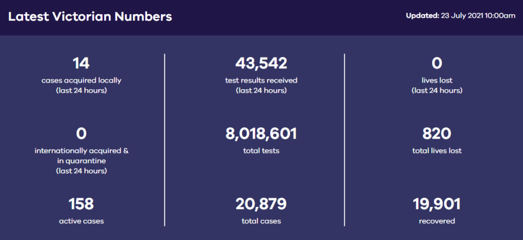
Statewide case numbers are subject to change as cases are reviewed and reclassified. Some postcode and local government information require to follow up and confirmation with a confirmed case and so is not added to the map until this process is completed by Victorian Public Health team.
Data on the table is presented by local government area active cases.
| LGA | lga_pid | Active | Total Cases | rate | new | |
| Alpine (S) | VIC242 | 0 | 1 | 0 | 0 | |
| Ararat (RC) | VIC220 | 0 | 6 | 0 | 0 | |
| Ballarat (C) | VIC241 | 0 | 58 | 0 | 0 | |
| Banyule (C) | VIC188 | 4 | 455 | 3 | 0 | |
| Bass Coast (S) | VIC173 | 0 | 10 | 0 | 0 | |
| Baw Baw (S) | VIC194 | 0 | 16 | 0 | 0 | |
| Bayside (C) | VIC182 | 3 | 269 | 2.8 | 0 | |
| Benalla (RC) | VIC199 | 0 | 4 | 0 | 0 | |
| Boroondara (C) | VIC201 | 21 | 292 | 11.5 | 4 | |
| Brimbank (C) | VIC189 | 9 | 2049 | 4.3 | 0 | |
| Buloke (S) | VIC183 | 0 | 0 | 0 | 0 | |
| Campaspe (S) | VIC239 | 0 | 10 | 0 | 0 | |
| Cardinia (S) | VIC212 | 0 | 201 | 0 | 0 | |
| Casey (C) | VIC213 | 3 | 1073 | 0.8 | 1 | |
| Central Goldfields (S) | VIC169 | 0 | 2 | 0 | 0 | |
| Colac-Otway (S) | VIC224 | 0 | 136 | 0 | 0 | |
| Corangamite (S) | VIC231 | 0 | 4 | 0 | 0 | |
| Darebin (C) | VIC205 | 2 | 693 | 1.2 | 1 | |
| East Gippsland (S) | VIC243 | 0 | 8 | 0 | 0 | |
| Frankston (C) | VIC227 | 1 | 243 | 0.7 | 1 | |
| Gannawarra (S) | VIC214 | 0 | 2 | 0 | 0 | |
| Glen Eira (C) | VIC177 | 15 | 249 | 9.6 | 2 | |
| Glenelg (S) | VIC223 | 0 | 19 | 0 | 0 | |
| Golden Plains (S) | VIC230 | 0 | 19 | 0 | 0 | |
| Greater Bendigo (C) | VIC193 | 1 | 102 | 0.8 | 0 | |
| Greater Dandenong (C) | VIC247 | 0 | 547 | 0 | 0 | |
| Greater Geelong (C) | VIC215 | 4 | 372 | 1.5 | 0 | |
| Greater Shepparton (C) | VIC93 | 0 | 53 | 0 | 0 | |
| Hepburn (S) | VIC94 | 0 | 2 | 0 | 0 | |
| Hindmarsh (S) | VIC152 | 0 | 0 | 0 | 0 | |
| Hobsons Bay (C) | VIC235 | 0 | 516 | 0 | 0 | |
| Horsham (RC) | VIC153 | 0 | 14 | 0 | 0 | |
| Hume (C) | VIC198 | 17 | 1679 | 7.3 | 1 | |
| Indigo (S) | VIC191 | 0 | 1 | 0 | 0 | |
| Kingston (C) | VIC226 | 2 | 305 | 1.2 | 0 | |
| Knox (C) | VIC209 | 0 | 165 | 0 | 0 | |
| Latrobe (C) | VIC219 | 0 | 53 | 0 | 0 | |
| Loddon (S) | VIC185 | 0 | 5 | 0 | 0 | |
| Macedon Ranges (S) | VIC228 | 0 | 58 | 0 | 0 | |
| Manningham (C) | VIC195 | 1 | 164 | 0.8 | 0 | |
| Mansfield (S) | VIC244 | 0 | 10 | 0 | 0 | |
| Maribyrnong (C) | VIC234 | 5 | 588 | 5.4 | 0 | |
| Maroondah (C) | VIC207 | 1 | 114 | 0.8 | 0 | |
| Melbourne (C) | VIC132 | 2 | 917 | 1.1 | 1 | |
| Melton (C) | VIC237 | 0 | 1146 | 0 | 0 | |
| Mildura (RC) | VIC222 | 4 | 10 | 7.2 | 0 | |
| Mitchell (S) | VIC211 | 0 | 90 | 0 | 0 | |
| Moira (S) | VIC190 | 0 | 11 | 0 | 0 | |
| Monash (C) | VIC210 | 7 | 352 | 3.5 | 1 | |
| Moonee Valley (C) | VIC121 | 5 | 831 | 3.8 | 0 | |
| Moorabool (S) | VIC236 | 6 | 43 | 17.1 | 0 | |
| Moreland (C) | VIC131 | 0 | 1061 | 0 | 0 | |
| Mornington Peninsula (S) | VIC204 | 1 | 183 | 0.6 | 0 | |
| Mount Alexander (S) | VIC105 | 0 | 9 | 0 | 0 | |
| Moyne (S) | VIC229 | 0 | 2 | 0 | 0 | |
| Murrindindi (S) | VIC250 | 0 | 9 | 0 | 0 | |
| Nillumbik (S) | VIC216 | 1 | 144 | 1.5 | 0 | |
| Northern Grampians (S) | VIC166 | 0 | 3 | 0 | 0 | |
| Other | 2 | 192 | 0 | 0 | ||
| Overseas Traveller | 12 | 226 | 0 | 0 | ||
| Port Phillip (C) | VIC208 | 3 | 315 | 2.6 | 0 | |
| Pyrenees (S) | VIC217 | 0 | 3 | 0 | 0 | |
| Queenscliffe (B) | VIC238 | 0 | 1 | 0 | 0 | |
| South Gippsland (S) | VIC178 | 0 | 14 | 0 | 0 | |
| Southern Grampians (S) | VIC233 | 0 | 2 | 0 | 0 | |
| Stonnington (C) | VIC203 | 3 | 264 | 2.5 | 0 | |
| Strathbogie (S) | VIC110 | 0 | 2 | 0 | 0 | |
| Surf Coast (S) | VIC225 | 0 | 13 | 0 | 0 | |
| Swan Hill (RC) | VIC180 | 0 | 6 | 0 | 0 | |
| Towong (S) | VIC187 | 0 | 0 | 0 | 0 | |
| Wangaratta (RC) | VIC186 | 0 | 2 | 0 | 0 | |
| Warrnambool (C) | VIC179 | 0 | 13 | 0 | 0 | |
| Wellington (S) | VIC218 | 1 | 18 | 2.3 | 0 | |
| West Wimmera (S) | VIC232 | 0 | 1 | 0 | 0 | |
| Whitehorse (C) | VIC196 | 2 | 220 | 1.1 | 1 | |
| Whittlesea (C) | VIC197 | 0 | 1227 | 0 | 0 | |
| Wodonga (RC) | VIC192 | 0 | 0 | 0 | 0 | |
| Wyndham (C) | VIC221 | 11 | 2265 | 4.1 | 1 | |
| Yarra (C) | VIC202 | 9 | 469 | 8.9 | 0 | |
| Yarra Ranges (S) | VIC206 | 0 | 247 | 0 | 0 | |
| Yarriambiack (S) | VIC200 | 0 | 1 | 0 | 0 |
Cases that are acquired overseas after December 1st, 2020 are recorded as residing in a default postcode of 9998 and Local Government Area of “Travel Overseas”. These entries are not displayed in the maps however are contained in the datasets.
South Australia Case numbers by location:
LGA Active Cases
Barossa 2
Playford 1
Salisbury 2
Tea Tree Gully 3
Adelaide 14
Burnside 1
Holdfast Bay 1
Onkaparinga 1
Total Active cases in South Australia are